

Digitizing Cerakah Forest Reserve : Marvel of Latest Technology in Conservation

In a pioneering leap for environmental conservation, the Planters is thrilled to unveil the successful digitization of a portion of the Cerakah Forest Reserve using cutting-edge SLAM technology. This technological marvel represents a significant advancement in our mission to safeguard Malaysia's invaluable forests and biodiversity.
Harnessing Cutting-Edge Technology:
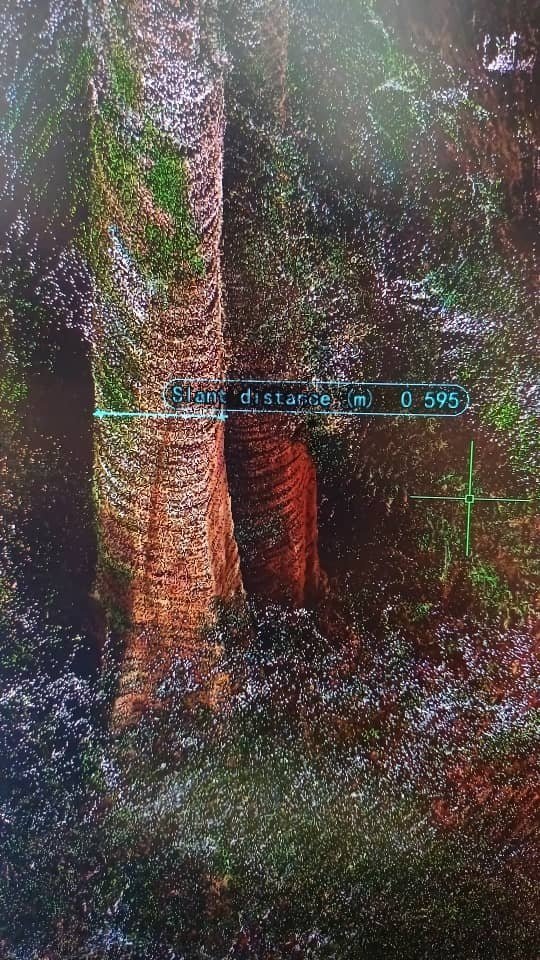
The digitization of Cerakah Forest Reserve was made possible through the use of Simultaneous Localization and Mapping (SLAM) technology. SLAM allows us to create detailed and accurate point clouds of the forest assets, including individual trees and topographic information. But what exactly does this mean, and why is it important?

Understanding SLAM:
Simultaneous Localization and Mapping (SLAM) is a technology that enables the creation of a map of an environment while simultaneously keeping track of an assets’s location within that environment. In the context of forest conservation, SLAM technology is utilized to capture high-resolution 3D data of the forest landscape. This includes the trees, the terrain, and various other ecological features.

The Benefits of Forest Digitization:
1. Accurate Data Capture:
- The SLAM technology ensures that we have precise and up-to-date information about the forest, mirroring the exact real conditions on the ground. This accuracy is crucial for effective conservation planning and implementation.
2. Enhanced Conservation Efforts:
- With detailed topographic and vegetative data, we can design better conservation strategies. Understanding the exact layout and composition of the forest allows us to target specific areas that need attention and resources.
3. Improved Reporting:
- Precise data from the digitized forest provides a robust foundation for transparent and reliable reporting. This is essential for tracking our progress, securing funding, and making informed decisions.
4. Better Data Validation:
- The precision scans provided by SLAM technology ensure that the data collected is highly accurate, allowing for better validation and verification. This level of detail helps in assessing the effectiveness of conservation efforts and making necessary adjustments.
5. Transparency:
- Utilizing SLAM technology in our conservation efforts enhances transparency. Stakeholders can access detailed maps and data, providing clear insights into the state of the forest and the progress of our initiatives. This openness builds trust and fosters stronger partnerships.
6. Advanced Post-Processing and Analysis:
- The detailed point clouds and topographic information captured through SLAM technology enable advanced post-processing and analysis. Researchers and conservationists can conduct in-depth studies, identify trends, and develop more effective strategies for forest management and preservation.


Join Us in Our Mission:
We invite you to join us in our conservation journey. Your support can help extend the scope of our efforts and make a significant impact on the preservation of our forests and biodiversity. By contributing to the Planters Initiative, you become a part of a larger mission to safeguard our environment for future generations.
Follow us for more updates and join the conversation on our conservation efforts!
#Planters #CerakahForestReserve #ForestConservation #SLAMTechnology #EnvironmentalConservation #DigitalForestry #GreenTechnology #Biodiversity #SaveOurPlanet #MalaysiaForests